Find Your Daily Voice
 45°
45°
Woman Hospitalized After Tree Falls On Merritt In Westport, Hitting Vehicles Amid Strong Winds
Two cars were hit by a tree on the Merritt Parkway and another hit the tree as it fell in the roadway in Fairfield County amid very windy conditions.
The incident occurred in Westport around 2:50 p.m. Monday, March 11, south of Exit 42, Connecticut State Police said.
The three vehicles, a Toyota Corolla, a Toyota Sienna, and a Nissan Altima, were traveling south on the parkway in the right lane when the tree fell, hitting the top of the first two vehicles.
The third vehicle hit the tree as it fell in the roadway, state police added.
Minor injuries were reported. All three vehicles r…
Man Accused Of Leaving Scene Of Fairfield County Crash, Police Say
A Fairfield County man has been arrested for allegedly crashing a vehicle and leaving the scene.
Emmanuel Segarra-Otero, age 30, of Stamford, was arrested on Friday, Aug. 6, after turning himself in to New Canaan in connection with the crash which took place on Saturday, June 12, on the Merritt Parkway, said New Canaan Police Lt. Jason Ferraro.
According to Ferraro, when officers arrived at the single-vehicle crash site, they located an unoccupied vehicle that had crashed into the guardrail on Old Stamford Road.
A subsequent investigation determined that Otero was the operator an…
Fairfield County Car Thief Rams Vehicles, Drives Into Oncoming Traffic, Police Say
Three Fairfield County men have been arrested after allegedly crashing into several police vehicles at the Westfield Trumbull Mall as they attempted to flee in a stolen vehicle.
During the incident, which took place on Monday, July 26, Dominique Reid, age 23, of Bridgeport, fled in the stolen Audi to avoid immediate capture, however, Hector Delgado, age 24, and Xavier Rondon, age 29, also of Bridgeport were immediately taken into police custody in the Westfield Mall parking lot, said Lieutenant Brian D. Weir.
Trumbull Police detectives initially located the Audi, which …
New Storm Could Bring Mix Of Snow, Ice, Causing Power Outages, Treacherous Travel
There's been no shortage of snowfall this winter.
But the main threat for the next storm taking aim on the region looks like it could be ice, leading to the possibility of potentially major power outages from damage to power lines and trees as well as treacherous travel.
The time frame for the storm, which could also bring accumulating snow to areas farther north and inland, is Saturday night, Feb. 13 through Valentine's Day, Sunday, Feb. 14, and into Presidents Day on Monday, Feb. 15.
Saturday, Feb. 13 will be mostly cloudy and cold with a high temperature in the upper 20s with wind…
Parking Garage Sells For $1.1 Million In Fairfield County
A Bridgeport parking garage sold to a Southport real-estate firm for $1,100,000.
According to Jon Angel, owner of real estate firm Angel Commercial, LLC, the 140-space, two-story parking garage at 95 Chapel Street, which was formerly owned by Geza Scap, was purchased on Monday, Sept. 21 by 38-2112th Street Partner, LLC of Amityville.
It is within walking distance of Superior Court, Bridgeport City Hall, Police Department, Downtown Cabaret Theater, Messiah Baptist Church, and apartment buildings, and is located less than a half a mile away from the Route 25 Connector, le…
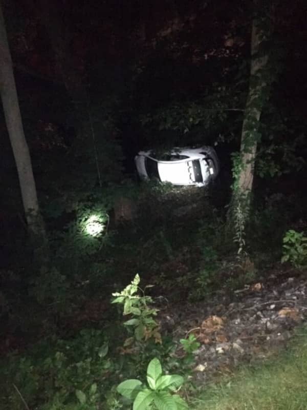
Woman Hospitalized After Car Crashes Off Merritt Parkway
A woman was hospitalized after her car crashed off the Merritt Parkway in Fairfield County overnight.
The incident happened around 4:30 a.m. Saturday, Sept. 5 in Norwalk.
When firefighters arrived with hospital paramedics and state police, the car, a Hyundai sedan, was found on its side, in a foot of water, between the parkway exit 40A ramp and the 1 Glover Avenue Condos, according to the Norwalk Fire Department.
The car appeared to have left the southbound exit ramp to Main Avenue and traveled 60 feet to the river below, the department said.
The driver, a woman in her 20s, walked up to f…
Tow Truck Driver Killed In Merritt Parkway Crash
A tow truck driver from an area company that has served Fairfield County for years, was hit and killed in a freak crash on the Merritt Parkway.
Corey John Iodice, 58, Seffner, Florida, was killed around 4:45 p.m., Wednesday, April 22, on the Parkway in the Trumbull area near Exit 47, said the Connecticut State Police.
According to police, the crash took place when Iodice, who was driving an Iodice Family Transport tow truck out of Fairfield, was attempting to load the disabled vehicle of a 25-year-old Bridgeport man.
While loading, a friend arrived to pick up the stranded man and was parke…